
Filtered By: Scitech
SciTech
The color of danger: PAGASA’s new rainfall and flood warning system
The colors red, green, and yellow —the same iconic symbols used in streets everywhere— are now given new meaning to alert the public of possible floods.
This June, the Philippine Atmospheric Geophysical and Astronomical Services Administration (PAGASA) started using a color-coded rainfall and flood warning system to help communities prepare for upcoming disasters.
Still in its pilot stage, the system is currently being tested in Metro Manila only, according to PAGASA weather specialist Maria Cristina Uson. The agency has yet to determine when to launch it nationwide.
In a nutshell, here is the tri-color warning system:
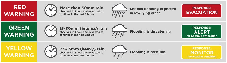
Yellow means “caution”. Residents are advised to monitor the news for further updates. “Yellow warning” represents 7.5-15 mm rain in an hour which could also cause flooding.Green means “go”. Go ahead and prepare for possible evacuation. “Green warning” stands for 15-30 mm rain in an hour that is also expected to continue within the next two hours. At this point, low-lying areas are expected to suffer from floods because of relatively heavy downpour. The memorable Typhoon Pedring (Nesat), which hit the country on September 27, 2011, fell within the green warning range as it had a recorded rainfall of about 15-25 mm per hour.Red means “stop”. Better stop what you are doing now if PAGASA says your area is under a “red warning.” Evacuate. Think about the amount of rain at Typhoon Ondoy’s (Ketsana) peak when it hit the country on September 26, 2009. The recorded rainfall at that time was approximately 56 mm in an hour. According to PAGASA, if more than 30mm rain is observed in an hour, and is expected to continue in the next two hours, then low-lying areas are expected to experience serious flooding. Residents in areas that have low elevation, such as coastal towns and cities, the CAMANAVA (Caloocan, Malabon, Navotas, Valenzuela) area, are advised to evacuate immediately.
Two-phase program
In a report earlier this year, the state weather bureau said that they patterned this system after Hong Kong Observatory’s three-level rainstorm alert system.
This rainfall warning system is a part of PAGASA’s two-phase program to improve their weather alerts.
Phase I is a public warning system specifically for thunderstorms. Currently, PAGASA is using thunderstorm alerts for specific areas throughout the Philippines, as shown by the weather bureau’s social media accounts.
Phase II, on the other hand, is for larger weather disturbances such as low pressure areas, tropical depressions, and tropical cyclones.
“The rainfall warning system is based on the intensity, characteristic and amount of rainfall,” said Uson.
System shortcomings
The current rainfall warning system has its shortcomings, however.
According to GMA’s resident meteorologist, Nathaniel Cruz, the quick-changing nature of weather disturbances makes the warning system only useful for relatively short periods of time.
“There might be times when, before you could alert the public, the rain has already stopped,” Cruz pointed out.
Cruz illustrated his point with Typhoon Ondoy in 2009 as an example: within a span of less than six hours, the conditions in Metro Manila had shifted from yellow to red.
“People might not be able to evacuate with that short span of time,” Cruz said.
“The public has long waited for an alert system like this, but it still needs improvement to be put to good use,” he added.
But so far, Uson said that the public has been mostly receptive to the new warning system. “Based on the past few weeks, we have been receiving positive feedback, like during tropical cyclone Ferdie,” she said.
Public storm signals
Public storm warning signals (PSWS) given during tropical cyclones should not be mistaken for rainfall and flood warnings.
According to the PAGASA website, the purpose of the PSWS number is to warn the public of specific weather conditions related to an oncoming tropical cyclone.
The PSWS is based not just on the amount of rainfall, but also on the strength and speed of the wind. Thus, the full impact of each PSWS signal is only felt after a certain lead time has passed.
The various PSWS levels are:
Public Storm Warning Signal #1. This means that strong winds of up to 60 kph are expected within 36 hours. Because of the long lead time, it’s common for people to think that the weather forecast is wrong. Damage is evident mostly on rice crops, light-weighed structures —nipa huts and cogon huts— and banana plants. Coastal communities are expected to be prepared for possible evacuation at any time. At this PSWS level, preschool classes within affected areas are automatically suspended.Public Storm Warning Signal #2. At this level, kids from preschool to high school “celebrate” because of class suspension. Within 24 hours, winds of 60 to 100 kph are expected. Not just crops but also galvanized roofs may be damaged from such winds. Travel by water, especially by boat and other small seacraft, should be avoided.Public Storm Warning Signal #3. Most offices and all schools up to colleges and universities are closed because it is dangerous for anyone to travel. Very strong winds of 100 to 185 kph are expected within 18 hours. Aside from the damages mentioned in the previous PSWS numbers, electricity and water supply may also be affected. Air and sea travel are both risky at this point. Classes in all levels are suspended. Communities affected should expect major damage to crops and property.At this point, communities should be wary of the “eye” of the storm. Winds are at their strongest nearest the eye, but die down to fair weather for about two hours as the eye passes over. After this, the storm resurges, bringing strong winds in the opposite direction.Public Storm Warning Signal #4. Winds with speed of over 185 kph are expected to hit the area within 12 hours. Residential, agricultural, and industrial properties may be severely damaged. Electricity and communication may also be disrupted. Residents along coastal areas and other danger zones are advised to evacuate as soon as possible.
Also, according to the PAGASA website, because cyclones move at different rates, the signal numbers may change depending on their movement and behavior.
— TJD, GMA News
